For recreational boaters, the most important GPS chartplotter features include precise GPS positioning, detailed charts, and easy waypoint marking to plan and adjust routes effortlessly. Real-time data and sensor integration help improve safety and situational awareness, while weather overlays allow you to anticipate hazards like storms and rough seas. These tools make navigation safer and more confident, especially in unfamiliar waters. Keep exploring to discover how these features can enhance your boating experience.
Key Takeaways
- Accurate GPS positioning ensures precise navigation and safe route planning for recreational boating.
- Real-time weather overlays help anticipate and avoid hazardous weather conditions on the water.
- Waypoint marking and route adjustments enable flexible trip planning and on-the-fly modifications.
- Integration with sensors and environmental data enhances situational awareness and safety.
- User-friendly interfaces simplify navigation, making trips safer and more enjoyable in unfamiliar waters.

GPS chartplotter is an essential tool for recreational boaters looking to steer safely and efficiently on the water. It’s your digital compass, combining precise positioning with detailed charts to help you steer clear of hazards and stay on course. When choosing a chartplotter, one key feature to consider is its ability to enhance marine navigation. Good marine navigation features include accurate GPS positioning, detailed chart overlays, and the ability to mark waypoints. These elements allow you to plan your route beforehand and adjust on the fly, even if you’re unfamiliar with the area. With reliable marine navigation, you won’t have to rely solely on traditional methods like visual cues or dead reckoning, which can be less accurate or risky in poor visibility. Additionally, many GPS chartplotters now incorporate real-time data updates, further improving navigation safety and precision. The integration of advanced sensor compatibility can also provide more comprehensive situational awareness, making your trips safer and more enjoyable. Weather integration is another essential feature that can markedly improve your boating experience. Modern GPS chartplotters often come with weather overlay capabilities, providing real-time updates on storms, wind speed, and wave conditions. This integration lets you anticipate and avoid dangerous weather, reducing the risk of getting caught in a storm or rough seas. It’s especially valuable if you’re planning longer trips or venturing into less familiar waters. Weather data displayed directly on your chartplotter means you can make quick, informed decisions without switching between multiple devices or apps. You can see how weather patterns shift in real-time, helping you choose the safest route and keep everyone onboard safe.
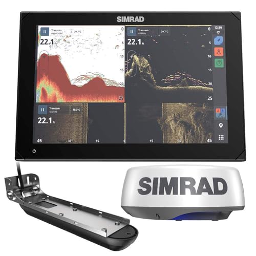
Simrad 000-15377-001, NSX 3009, Chartplotter and Fishfinder with Active Imaging 3-in-1 Transducer, HALO20+ Radar and C-MAP Discover X Charts, 9 Inch, Black
- Display Size: 9-inch high-definition IPS touchscreen
- Viewing Angles: Extreme viewing angles, polarized lens compatible
- Charting: C-MAP Discover X with updates and support for Reveal X
As an affiliate, we earn on qualifying purchases.
As an affiliate, we earn on qualifying purchases.
Frequently Asked Questions
How Do GPS Chartplotters Improve Safety on the Water?
GPS chartplotters improve safety on the water by enhancing maritime navigation, helping you avoid hazards and stay on course. They provide real-time location updates, making it easier to track your position and plan routes accurately. Additionally, many models include emergency signaling features, allowing you to send distress signals quickly if needed. This combination of precise navigation and emergency capabilities reduces risks, ensuring you stay safe during your boating adventures.
Can GPS Chartplotters Be Integrated With Other Onboard Systems?
Yes, GPS chartplotters can be integrated with other onboard systems, and the possibilities might surprise you. With advanced navigation integration and system compatibility, your chartplotter can connect seamlessly with radar, autopilot, and sonar systems. This integration enhances your boating experience, providing real-time data and coordinated control. Imagine the confidence you’ll feel knowing all your systems work together effortlessly, turning complex navigation into a smooth, connected experience on the water.
What Is the Typical Lifespan of a GPS Chartplotter Device?
A typical GPS chartplotter device lasts about 5 to 10 years, depending on usage and technological advances. GPS technology evolves quickly, so you might consider chartplotter upgrades to stay current with features like better mapping and connectivity. Proper maintenance can prolong its lifespan, but eventually, hardware becomes outdated. Regular updates and careful handling ensure you get the most out of your device during its years of service.
Are There Any Maintenance Tips for Prolonging Chartplotter Performance?
To prolong your chartplotter’s performance, regularly perform software updates to fix bugs and improve functionality. Keep the screen calibrated to guarantee accurate readings, especially after exposure to water or temperature changes. Clean the screen gently with a soft cloth, avoiding harsh chemicals. Check connections periodically for corrosion or damage. These simple maintenance tips help your device operate smoothly, ensuring reliable navigation whenever you need it most.
How User-Friendly Are Advanced GPS Chartplotter Features for Beginners?
Beginners benefit from a user-friendly interface that simplifies scanning, setting, and steering. Many advanced GPS chartplotters offer straightforward screens and intuitive icons, making mastery manageable. Additionally, beginner tutorials provide step-by-step support, easing users into essential features. With clear commands and helpful hints, even novices can navigate networks naturally, gaining confidence. Overall, modern chartplotters are designed to delight beginners, making data deciphering both doable and enjoyable.
Conclusion
Just like Odysseus relied on his trusty compass to find his way home, your GPS chartplotter becomes your navigation hero on the water. By choosing the right features, you guarantee smoother voyages and safer adventures. Remember, the sea’s mysteries are vast, but with the right technology, you hold the key to exploring confidently. Embrace these features, and let your journey be as legendary as the stories of old.