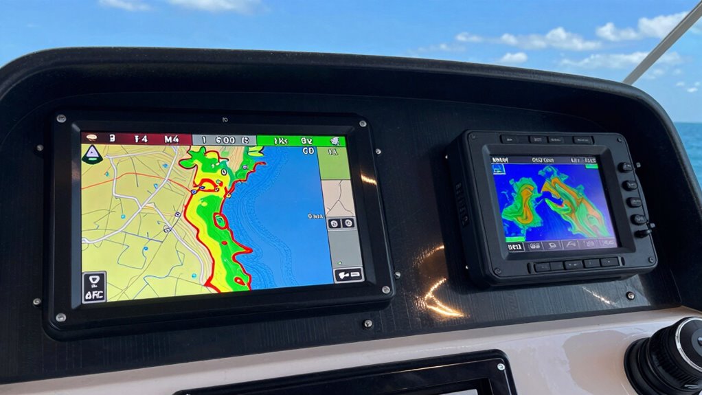

If you’re looking for the best GPS chartplotters with sonar for 2026 that coastlines love, I recommend checking out models with high-res displays, advanced sonar like CHIRP and SideVü, and reliable navigation features. Brands like Garmin, Raymarine, and Simrad offer options packed with detailed mapping, real-time imaging, and easy-to-use controls. These systems are tough, weather-resistant, and compatible with multiple transducers. Keep exploring further, and you’ll discover the perfect fit for your boating adventures.
Key Takeaways
- Highlights top GPS chartplotters with advanced sonar and mapping features ideal for coastal and inland fishing in 2026.
- Focuses on high-resolution displays, user-friendly interfaces, and customizable layouts for easy navigation.
- Emphasizes support for cutting-edge sonar technologies like CHIRP, SideVü, and LiveScope for detailed underwater imaging.
- Includes models with comprehensive mapping options, real-time mapping, and compatibility with premium charts and updates.
- Details durable, weather-resistant designs with versatile connectivity and system integration for reliable coastal use.
| Raymarine Element 7 HV Chart Plotter with Sonar | 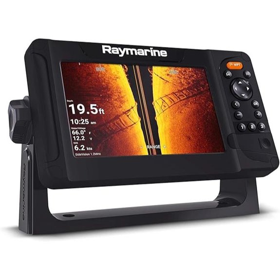 | Advanced Sonar Leader | Display Size: 7-inch | Sonar Support: HyperVision CHIRP, RealVision 3D | Mapping/Charts Included: Lighthouse North America | VIEW LATEST PRICE | See Our Full Breakdown |
| Garmin UHD2 93sv Chartplotter with Transducer |  | User-Friendly Power | Display Size: 9-inch | Sonar Support: Traditional, ClearVü, SideVü | Mapping/Charts Included: Garmin Navionics+ inland | VIEW LATEST PRICE | See Our Full Breakdown |
| Garmin ECHOMAP UHD2 54CV Chartplotter/Fishfinder | 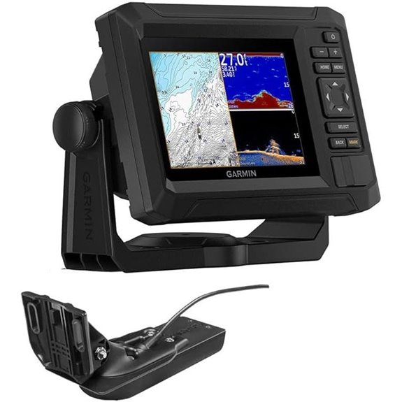 | Versatile Marine Mapper | Display Size: 5-inch | Sonar Support: Traditional, ClearVü, SideVü | Mapping/Charts Included: LakeVü g3, BlueChart g3, Navionics+ | VIEW LATEST PRICE | See Our Full Breakdown |
| Garmin ECHOMAP Ultra 2 12″ Chartplotter & LiveScope | 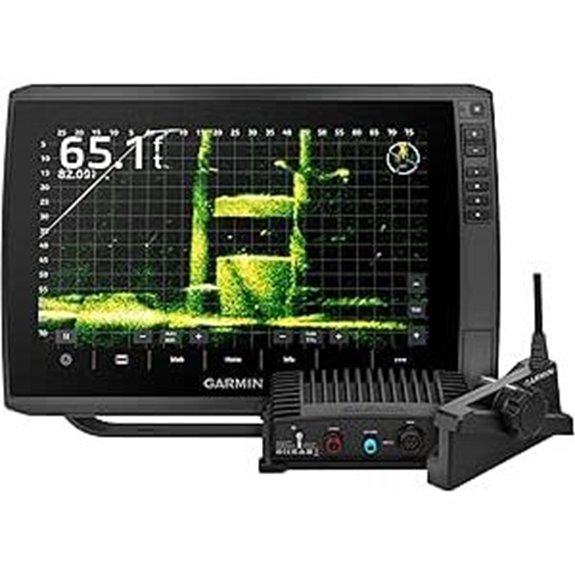 | Premium All-in-One | Display Size: 12-inch | Sonar Support: CHIRP, ClearVu, SideVu, LiveScope | Mapping/Charts Included: Navionics+ charts | VIEW LATEST PRICE | See Our Full Breakdown |
| Simrad GO Chartplotter Fish Finder with Transducer | 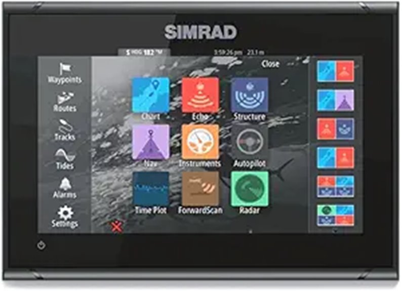 | High-Performance Display | Display Size: 9-inch | Sonar Support: CHIRP, DownScan | Mapping/Charts Included: C-MAP Discover | VIEW LATEST PRICE | See Our Full Breakdown |
| Humminbird Helix | 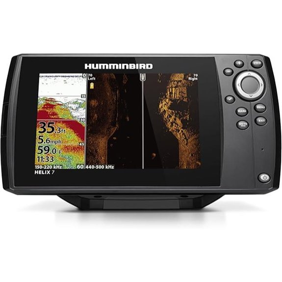 | Real-Time Mapping | Display Size: Not specified (integrated display) | Sonar Support: Dual Spectrum CHIRP, AutoChart Live | Mapping/Charts Included: Basemap, AutoChart Live, compatible with LakeMaster/Navionics | VIEW LATEST PRICE | See Our Full Breakdown |
| Humminbird Helix 7 G4N GPS Fish Finder | 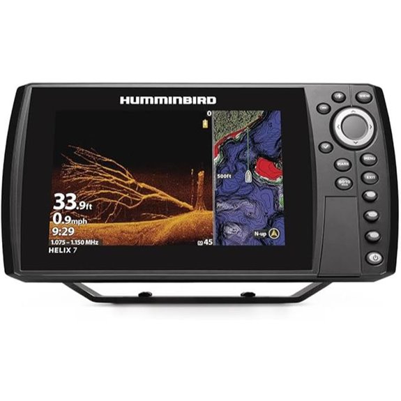 | High-Definition Imaging | Display Size: 7-inch | Sonar Support: MEGA Down Imaging, Dual Spectrum CHIRP | Mapping/Charts Included: Basemap, AutoChart Live, compatible with Navionics, LakeMaster | VIEW LATEST PRICE | See Our Full Breakdown |
| Humminbird 411670-1 Helix 5 Chirp DI GPS G3 Fish Finder | 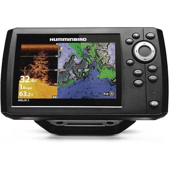 | Large Screen Flexibility | Display Size: 5-inch | Sonar Support: CHIRP, Down Imaging | Mapping/Charts Included: Basemap, AutoChart Live, Navionics+ | VIEW LATEST PRICE | See Our Full Breakdown |
| Garmin ECHOMAP UHD2 73sv Chartplotter with Transducer | 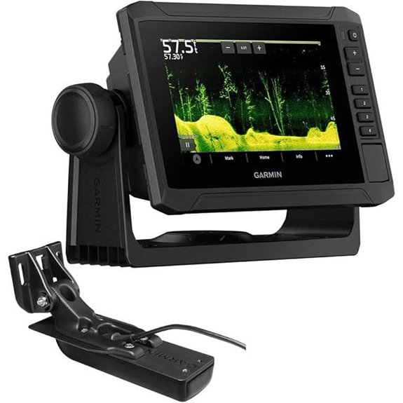 | Sharp Navigation | Display Size: 7-inch | Sonar Support: Traditional, ClearVü, SideVü | Mapping/Charts Included: Navionics+ inland | VIEW LATEST PRICE | See Our Full Breakdown |
| Garmin ECHOMAP UHD2 53CV Chartplotter/Fishfinder | 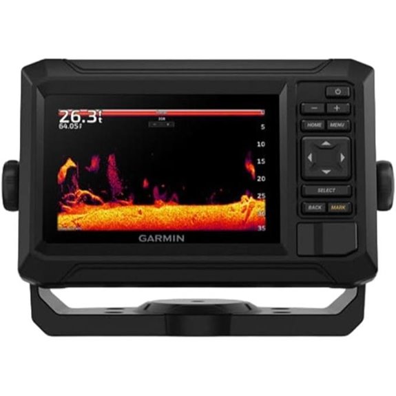 | Comprehensive System | Display Size: 5-inch | Sonar Support: CHIRP, ClearVü | Mapping/Charts Included: Navionics+ inland | VIEW LATEST PRICE | See Our Full Breakdown |
| Humminbird 411660-1 Helix 5 Chirp GPS G3 Fish Finder | 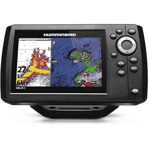 | Compact Precision | Display Size: 5-inch | Sonar Support: Dual Spectrum CHIRP, Down Imaging | Mapping/Charts Included: Basemap, AutoChart Live, Navionics+ | VIEW LATEST PRICE | See Our Full Breakdown |
| Simrad GO Chartplotter Fish Finder with Transducer | 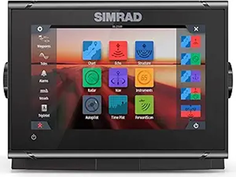 | Budget Marine Choice | Display Size: 9-inch | Sonar Support: CHIRP, SideScan, DownScan | Mapping/Charts Included: C-MAP DISCOVER | VIEW LATEST PRICE | See Our Full Breakdown |
| Simrad GO Chartplotter Fish Finder with Transducer | 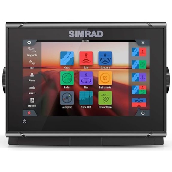 | Feature-Rich Versatile | Display Size: 9-inch | Sonar Support: Active Imaging 3-in-1, CHIRP, SideScan, DownScan | Mapping/Charts Included: Multiple charts including C-MAP, Navionics, Insight | VIEW LATEST PRICE | See Our Full Breakdown |
| Garmin ECHOMAP UHD2 94sv Chartplotter with Transducer | 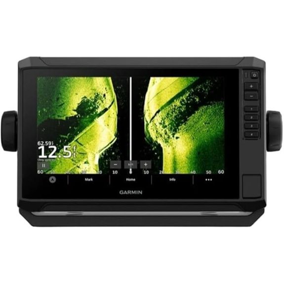 | Top-Tier Integration | Display Size: 9-inch | Sonar Support: CHIRP, ClearVü, SideVü | Mapping/Charts Included: Navionics+ U.S. Coastal | VIEW LATEST PRICE | See Our Full Breakdown |
More Details on Our Top Picks
Raymarine Element 7 HV Chart Plotter with Sonar
If you’re serious about both navigation and fishing, the Raymarine Element 7 HV Chart Plotter with Sonar is an excellent choice because of its ultra-high-resolution HyperVision CHIRP sonar and fast processing power. Its 7-inch high-res display offers clear, detailed visuals, while built-in GPS ensures precise positioning. Wi-Fi connectivity makes updates simple, and the Lighthouse North America Chart covers US and Canada waters. The all-in-one HV-100 transducer supports multiple sonar modes, including CHIRP down, side, and 3D imaging. The powerful quad-core processor delivers instant chart redraws, providing real-time, detailed underwater views for confident navigation and successful fishing.
- Display Size:7-inch
- Sonar Support:HyperVision CHIRP, RealVision 3D
- Mapping/Charts Included:Lighthouse North America
- Connectivity Features:Wi-Fi for updates/data sharing
- Screen Technology:High-resolution display
- Mounting Options:No specific mount info
- Additional Feature:HyperVision 3D Sonar Support
- Additional Feature:Built-in Lighthouse North America Charts
- Additional Feature:Fast Quad-Core Processor
Garmin UHD2 93sv Chartplotter with Transducer
The Garmin UHD2 93sv Chartplotter with Transducer stands out as an excellent choice for anglers and boaters who need a high-resolution display combined with advanced sonar capabilities. Its 9-inch sunlight-readable touchscreen offers bright, clear visuals with improved detail and viewing angles, making navigation and fishing easier. The included GT56-TM transducer supports Garmin traditional, ClearVü, and SideVü scanning sonars, giving me versatile underwater views. I appreciate the built-in Garmin Navionics+ maps, covering over 18,000 lakes with detailed contours. Plus, its Wi-Fi lets me wirelessly share data and connect to my Force trolling motor for seamless route planning, navigation, and real-time control.
- Display Size:9-inch
- Sonar Support:Traditional, ClearVü, SideVü
- Mapping/Charts Included:Garmin Navionics+ inland
- Connectivity Features:Wi-Fi, wireless sharing, remote control
- Screen Technology:Sunlight-readable touchscreen
- Mounting Options:Not specified
- Additional Feature:Bright Sunlight-Readable Screen
- Additional Feature:Wireless Trolling Motor Control
- Additional Feature:Supports Garmin Navionics+ Maps
Garmin ECHOMAP UHD2 54CV Chartplotter/Fishfinder
For boaters seeking a reliable combination of detailed mapping and high-quality sonar, the Garmin ECHOMAP UHD2 54CV Chartplotter/Fishfinder stands out as an excellent choice. It features a bright 5-inch display and dual sonar capabilities—Garmin CHIRP traditional and ClearVü scanning—for crisp underwater views. Preloaded with LakeVü g3 inland maps, BlueChart g3 coastal charts, and a worldwide basemap, it offers versatile navigation options. Wi-Fi allows for easy sharing of data between devices, while the built-in ActiveCaptain app provides updates, community insights, and OneChart™ support. Overall, this device combines precise mapping with powerful sonar, making it a top pick for anglers and cruisers alike.
- Display Size:5-inch
- Sonar Support:Traditional, ClearVü, SideVü
- Mapping/Charts Included:LakeVü g3, BlueChart g3, Navionics+
- Connectivity Features:Wi-Fi, wireless sharing
- Screen Technology:WVGA IPS display
- Mounting Options:Flush or bail mount
- Additional Feature:Supports Multiple Transducer Types
- Additional Feature:Compatible with ActiveCaptain App
- Additional Feature:Preloaded LakeVü g3 Maps
Garmin ECHOMAP Ultra 2 12″ Chartplotter & LiveScope
The Garmin ECHOMAP Ultra 2 12″ Chartplotter with LiveScope stands out as a top choice for serious anglers who demand detailed underwater views and precise navigation. Its bright, high-resolution display with hybrid touch controls makes reading charts and sonar images easy. Preloaded with Garmin Navionics+ charts, it covers U.S. inland and coastal waters. The advanced CHIRP sonar and LiveScope Plus system deliver real-time, high-def underwater visuals. With multi-constellation GPS support, wireless pairing, and seamless system integration, it offers reliable performance. Weighing 14 pounds, it’s a powerful, versatile tool that elevates any fishing experience.
- Display Size:12-inch
- Sonar Support:CHIRP, ClearVu, SideVu, LiveScope
- Mapping/Charts Included:Navionics+ charts
- Connectivity Features:Wi-Fi, wireless sharing, Force motor control
- Screen Technology:Multi-touch, high-res display
- Mounting Options:Multiple mounting options
- Additional Feature:Built-in LiveScope Plus System
- Additional Feature:Multi-Constellation (GPS, GLONASS, GALILEO)
- Additional Feature:Supports Wireless Device Pairing
Simrad GO Chartplotter Fish Finder with Transducer
Looking for a reliable chartplotter that combines intuitive control with advanced sonar technology? The Simrad GO Fish Finder with Transducer delivers with its crisp 9-inch touchscreen, making steering straightforward. Its 83/200 HDI transducer offers CHIRP sonar and DownScan Imaging, giving me clear views of fish and underwater structures. Preloaded with C-MAP Discover charts, it covers coastal and inland areas with smart routing. Built-in GPS, Wi-Fi, and NMEA 2000 compatibility ensure seamless connectivity. Plus, it’s radar-ready and autopilot-compatible, making it versatile for any fishing adventure. Overall, it’s a powerful, user-friendly system perfect for guiding and fishing with confidence.
- Display Size:9-inch
- Sonar Support:CHIRP, DownScan
- Mapping/Charts Included:C-MAP Discover
- Connectivity Features:Wi-Fi, NMEA 2000, radar-ready
- Screen Technology:Touchscreen display
- Mounting Options:Not specified
- Additional Feature:Preloaded C-MAP Discover Charts
- Additional Feature:Radar-Ready for Expansion
- Additional Feature:NMEA 2000 Compatibility
Humminbird Helix
Humminbird Helix stands out with its Dual Spectrum CHIRP Sonar, offering both Wide and Narrow search modes that deliver detailed scans and broad coverage. I love how it provides precise 2D target separation with a Low-Q transducer, showing clear fish arches and structure views. Its Humminbird Basemap covers over 10,000 lakes and U.S. coastlines, and it’s compatible with premium charts like LakeMaster, CoastMaster, and Navionics. Plus, AutoChart Live lets me create real-time maps of depth, bottom hardness, and vegetation. The intuitive keypad control makes navigation simple, even in rough conditions, making the Helix a versatile choice for serious anglers.
- Display Size:Not specified (integrated display)
- Sonar Support:Dual Spectrum CHIRP, AutoChart Live
- Mapping/Charts Included:Basemap, AutoChart Live, compatible with LakeMaster/Navionics
- Connectivity Features:NMEA 2000, Bluetooth, Wi-Fi
- Screen Technology:Color TFT, keypad control
- Mounting Options:Not specified
- Additional Feature:AutoChart Live Real-Time Mapping
- Additional Feature:Dual Spectrum CHIRP Sonar
- Additional Feature:Over 10,000 Lake Coverage
Humminbird Helix 7 G4N GPS Fish Finder
If you’re serious about catching fish, the Humminbird Helix 7 G4N GPS Fish Finder stands out with its MEGA Down Imaging technology, delivering detailed views up to 125 feet beneath your boat—three times more detailed than standard sonar. This clarity reveals fish, structures, and contours with remarkable precision. It also features dual spectrum CHIRP sonar, offering wide coverage or focused scanning for better target separation. With enhanced GPS, it maps over 10,000 lakes and coastlines, plus real-time depth contours with AutoChart Live. The intuitive display and seamless connectivity make this unit a powerful tool for anglers seeking accuracy and detail on the water.
- Display Size:7-inch
- Sonar Support:MEGA Down Imaging, Dual Spectrum CHIRP
- Mapping/Charts Included:Basemap, AutoChart Live, compatible with Navionics, LakeMaster
- Connectivity Features:Ethernet, Bluetooth, NMEA 2000
- Screen Technology:Touchscreen, advanced imaging
- Mounting Options:Not specified
- Additional Feature:Ethernet & Bluetooth Connectivity
- Additional Feature:Supports Minn Kota & Cannon
- Additional Feature:MEGA Down Imaging Technology
Humminbird 411670-1 Helix 5 Chirp DI GPS G3 Fish Finder
For anglers seeking precise underwater imaging combined with reliable navigation, the Humminbird 411670-1 Helix 5 Chirp DI GPS G3 Fish Finder is an excellent choice. It features CHIRP Down Imaging for clear views beneath your boat and CHIRP Digital Sonar for detailed scans. Dual Spectrum CHIRP Sonar offers wide coverage and fine detail, while the built-in GPS with Humminbird Basemap covers over 10,000 lakes and coastlines. The device’s user-friendly keypad, real-time mapping with AutoChart Live, and pre-loaded views make it easy to operate in any conditions. Its 5-inch color display packs impressive features into a compact, durable design perfect for serious anglers.
- Display Size:5-inch
- Sonar Support:CHIRP, Down Imaging
- Mapping/Charts Included:Basemap, AutoChart Live, Navionics+
- Connectivity Features:Wi-Fi, NMEA 2000
- Screen Technology:Color TFT, keypad control
- Mounting Options:Gimbal, flush mount
- Additional Feature:8 Hours Recording with AutoChart
- Additional Feature:Gimbal & Flush Mounts
- Additional Feature:Compatible with LakeMaster Charts
Garmin ECHOMAP UHD2 73sv Chartplotter with Transducer
The Garmin ECHOMAP UHD2 73sv Chartplotter with Transducer stands out as an excellent choice for anglers and boaters seeking a versatile, easy-to-use navigation system. Its 7-inch sunlight-readable touchscreen ensures clear visibility in all lighting conditions. The included GT54-TM transducer supports Garmin traditional sonar, ClearVü, and SideVü scanning, providing detailed underwater views. Built-in Garmin Navionics+ maps cover over 18,000 lakes with 1-foot contours, enhancing inland navigation. Wireless features like Wi-Fi sharing, route creation, and compatibility with Force trolling motors make this device highly user-friendly. It’s a reliable, multifunctional tool for both fishing and boating adventures.
- Display Size:7-inch
- Sonar Support:Traditional, ClearVü, SideVü
- Mapping/Charts Included:Navionics+ inland
- Connectivity Features:Wi-Fi, wireless sharing
- Screen Technology:Sunlight-readable touchscreen
- Mounting Options:Not specified
- Additional Feature:Supports Garmin ClearVü & SideVü
- Additional Feature:Built-in Tides & Currents Data
- Additional Feature:Supports Wireless Data Sharing
Garmin ECHOMAP UHD2 53CV Chartplotter/Fishfinder
The Garmin ECHOMAP UHD2 53CV stands out as an excellent choice for anglers seeking both detailed navigation and fishing insights. Its 5-inch color display delivers clear, vibrant images, supporting Garmin CHIRP traditional sonar and ClearVü scanning sonar for precise underwater views. Preloaded with Garmin Navionics+ U.S. Inland Maps, it offers extensive navigation right out of the box. The Wi-Fi connectivity makes sharing data between compatible units simple and quick. Plus, it comes with the GT20-TM transducer, combining chartplotter and fishfinder functions in a versatile device perfect for inland and coastal adventures alike.
- Display Size:5-inch
- Sonar Support:CHIRP, ClearVü
- Mapping/Charts Included:Navionics+ inland
- Connectivity Features:Wi-Fi, wireless sharing
- Screen Technology:Color display
- Mounting Options:Not specified
- Additional Feature:US Inland Mapping Included
- Additional Feature:Supports Garmin CHIRP & ClearVü
- Additional Feature:Compact 5-Inch Display
Humminbird 411660-1 Helix 5 Chirp GPS G3 Fish Finder
If you’re looking for a compact yet powerful fish finder, the Humminbird 411660-1 Helix 5 Chirp GPS G3 stands out with its Dual Spectrum CHIRP Sonar, offering detailed fish arches and structure views. It features two search modes: Wide Mode for broad coverage and Narrow Mode for precise scanning. The 5-inch color display provides clear visuals, and the user-friendly keypad makes navigation simple. With Humminbird Basemap covering over 10,000 lakes and coastlines, plus support for premium charts, it’s perfect for versatile fishing. Real-time mapping with AutoChart Live enhances your understanding of underwater terrain, making this a reliable, all-in-one solution.
- Display Size:5-inch
- Sonar Support:Dual Spectrum CHIRP, Down Imaging
- Mapping/Charts Included:Basemap, AutoChart Live, Navionics+
- Connectivity Features:Wi-Fi, NMEA 2000
- Screen Technology:Color display
- Mounting Options:Gimbal, gimbal bracket
- Additional Feature:Supports AutoChart Live Mapping
- Additional Feature:Compatible with Multiple Charts
- Additional Feature:User-Friendly Keypad Control
Simrad GO Chartplotter Fish Finder with Transducer
Designed for serious anglers and boaters seeking an all-in-one navigation and fish-finding solution, the Simrad GO Chartplotter Fish Finder with Transducer stands out with its versatile multifunction display. It combines GPS, sonar, and radar functions, perfect for sportboats and cruisers. The preloaded C-MAP DISCOVER card offers detailed charts, tides, currents, and bathymetric contours, covering the US and Canada. Its Active Imaging 3-in-1 transducer provides CHIRP, SideScan, and DownScan imaging, delivering detailed visuals of structures and fish. Plus, it supports radar connectivity, smartphone mirroring, and NMEA 2000 integration, making it a all-encompassing choice for navigation and fishing.
- Display Size:9-inch
- Sonar Support:CHIRP, SideScan, DownScan
- Mapping/Charts Included:C-MAP DISCOVER
- Connectivity Features:NMEA 2000, Wi-Fi
- Screen Technology:Multi-touch, high-res display
- Mounting Options:Not specified
- Additional Feature:Plug-and-Play Radar Support
- Additional Feature:Detailed Bathymetric Contours
- Additional Feature:High-Resolution Active Imaging
Simrad GO Chartplotter Fish Finder with Transducer
For anglers and boaters seeking a versatile and easy-to-use navigation system, the Simrad GO9 XSE Fish Finder with Transducer stands out thanks to its intuitive multi-touch display and all-encompassing sonar capabilities. It offers customizable layouts, support for top cartography options, and a built-in 10 Hz GPS for precise positioning. The Active Imaging 3-in-1 transducer delivers CHIRP, SideScan, and DownScan imaging, capturing detailed structures and fish. With optional ForwardScan, NMEA 2000 connectivity, and a dedicated Cruise Charting page, this device simplifies navigation and enhances fishing efficiency, making it a well-rounded choice for water enthusiasts.
- Display Size:9-inch
- Sonar Support:Active Imaging 3-in-1, CHIRP, SideScan, DownScan
- Mapping/Charts Included:Multiple charts including C-MAP, Navionics, Insight
- Connectivity Features:NMEA 2000, Wi-Fi, remote mirroring
- Screen Technology:Multi-touch, bright display
- Mounting Options:Mounting hardware included
- Additional Feature:Multi-View Custom Layouts
- Additional Feature:ForwardScan Sonar Support
- Additional Feature:Cruise Charting Page
Garmin ECHOMAP UHD2 94sv Chartplotter with Transducer
The Garmin ECHOMAP UHD2 94sv Chartplotter with Transducer stands out with its bright 9-inch sunlight-readable touchscreen, making it an excellent choice for anglers and boaters who need clear, detailed visuals in any lighting conditions. Its improved display offers better clarity, viewing angles, and ease of use. The included GT56-TM transducer supports Garmin traditional sonar, ClearVü, and SideVü scanning sonar, providing versatile imaging. It comes preloaded with Garmin Navionics+ U.S. Coastal charts, and its built-in Wi-Fi allows wireless sharing of waypoints, routes, and sonar data. Plus, it connects to Force trolling motors for streamlined navigation and control.
- Display Size:9-inch
- Sonar Support:CHIRP, ClearVü, SideVü
- Mapping/Charts Included:Navionics+ U.S. Coastal
- Connectivity Features:Wi-Fi, wireless sharing
- Screen Technology:Sunlight-readable touchscreen
- Mounting Options:Not specified
- Additional Feature:Improved Display Clarity
- Additional Feature:Supports Garmin Navionics+
- Additional Feature:Wireless Sharing to Multiple Units
Factors to Consider When Choosing GPS Chartplotters With Sonar
When choosing a GPS chartplotter with sonar, I focus on display size and clarity to guarantee easy navigation. I also consider sonar technology quality and mapping options, so I get accurate readings and detailed charts. Additionally, connectivity features and transducer compatibility play a big role in making sure the device suits my specific needs.
Display Size and Clarity
Choosing a GPS chartplotter with sonar means paying close attention to display size and clarity, as these factors considerably impact your ability to interpret charts and underwater images quickly and accurately. A larger display, such as 9 inches or more, enhances visibility and makes it easier to read detailed charts and sonar images at a glance. High-resolution screens deliver sharper visuals, helping you distinguish fish, structures, and underwater contours clearly. Sunlight-readable screens with anti-glare coatings are essential for outdoor visibility in bright conditions. Improved viewing angles ensure consistent clarity from different positions around the boat, reducing the need to reposition the device. Bright, vivid color displays with high contrast further improve your ability to differentiate water depths, fish, and underwater features effectively.
Sonar Technology Quality
High-quality sonar technology like CHIRP markedly enhances your underwater imaging by delivering sharper target separation and reducing noise, which makes it easier to identify fish and structures. This technology provides detailed imaging that reveals even subtle underwater features. Advanced imaging features like DownScan, SideVü, or RealVision 3D further improve target clarity, helping you distinguish fish from debris or structures. The frequency range, such as 70/83/200 kHz, directly impacts resolution and depth; higher frequencies excel in shallow water with finer detail, while lower frequencies reach deeper. Dual or multi-frequency transducers add versatility, enabling detection across various environments. The overall quality of sonar image processing, including real-time rendering and enhanced color palettes, significantly boosts underwater visibility and target clarity.
Mapping and Chart Coverage
A GPS chartplotter’s mapping and chart coverage capabilities directly impact how well I can navigate and locate underwater features in my usual boating areas. I look for detailed inland and coastal maps with high-resolution contours to guarantee accurate navigation. It’s crucial to verify the coverage area, whether it includes lakes, rivers, or coastal regions I frequent. I also check if the device supports additional map upgrades or third-party charts like Navionics or LakeMaster to expand coverage as needed. Real-time mapping features, such as AutoChart Live, are valuable for creating custom maps of underwater structures. Lastly, I consider how often the charts are updated and whether the device can connect to online sharing platforms to keep my navigation data current.
Connectivity Options
Connectivity options play a critical role in maximizing the functionality of GPS chartplotters with sonar, especially when I want seamless data sharing and system integration. I look for units with built-in Wi-Fi or Bluetooth, which make updates and data transfer effortless without cables. Supporting NMEA 2000 is necessary for integrating with other marine systems like autopilots and engine monitors, creating a unified navigation experience. Compatibility with mobile apps or remote devices allows me to control the system and access data wirelessly, even from afar. Connecting to trolling motors or sensors provides real-time information, enhancing navigation accuracy. Ultimately, multi-device networking ensures all units work synchronously, which is indispensable on larger vessels. These connectivity features considerably improve my overall boating experience, making my systems smarter and more responsive.
Transducer Compatibility
Choosing the right transducer is vital to getting accurate and detailed sonar images from your GPS chartplotter. First, I verify the chartplotter supports the transducer types I plan to use, like CHIRP, SideVü, or ClearVü, for peak performance. I also confirm that the transducer’s frequency range matches the sonar technology supported, such as 70/200 kHz or 83/200 kHz. Compatibility with my watercraft and mounting options is important, so I check if the transducer fits my boat’s setup. Power requirements and connector types must align with the chartplotter’s specifications for seamless integration. Finally, I consider if the transducer supports advanced features like RealVision 3D or LiveScope and verify the chartplotter can handle these capabilities for future upgrades.
User Interface Ease
When selecting a GPS chartplotter with sonar capabilities, the user interface plays a key role in how smoothly I can operate the device. An intuitive layout with clearly labeled menus and icons makes navigation straightforward, reducing my learning curve. Responsive touchscreen controls with multi-touch gestures allow me to access functions quickly, even in challenging weather conditions. When needed, physical control buttons and softkey menus offer reliable alternatives, especially when I wear gloves. Customizable display layouts and shortcuts help me tailor the interface to my specific fishing or navigation needs, saving time and effort. Additionally, high-contrast visuals with adjustable brightness and contrast ensure readability in bright sunlight or low-light environments, making the device easier to use in all conditions.
Power and Processing
A high-performance processor is vital for a GPS chartplotter with sonar, as it handles real-time data rendering and complex mapping tasks smoothly. A quad-core or multi-core CPU ensures fast processing speeds, enabling instant chart redraws and quick responses to user inputs. This is especially important when integrating multiple data streams like sonar imaging, navigation, and mapping simultaneously. Advanced sonar technologies such as HyperVision CHIRP or ClearVü require significant processing power to produce high-resolution underwater imagery in real-time. Systems supporting multi-constellation GPS, including GPS, GLONASS, GALILEO, and BEIDOU, also demand robust processing capabilities to accurately combine signals for precise positioning. Adequate power and processing are vital for enabling features like 3D rendering, live mapping, and real-time sonar imaging, elevating your navigation and fishing experience.
Durability and Waterproofing
Durability and waterproofing are critical factors because marine environments expose GPS chartplotters to moisture, salt, and physical impacts that can damage sensitive components. I always verify a device has an IPX7 or higher waterproof rating, meaning it can handle splashes, rain, and brief submersion without issue. Rugged, sealed enclosures made from corrosion-resistant materials like high-grade plastics or stainless steel are essential for longevity in harsh conditions. The display should be protected by chemically resistant, anti-glare, high-impact glass or polycarbonate to prevent damage from debris and UV exposure. I also check the ingress protection (IP) rating to confirm resistance to dust and water. Reinforced mounting brackets and sealed connection ports further safeguard the unit, ensuring reliable performance over time.
Frequently Asked Questions
How Do GPS Chartplotters Enhance Fishing Success on Coastal Waters?
GPS chartplotters boost my fishing success by guiding me precisely to hotspots, even in tricky coastal waters. I can mark productive spots, track my routes, and navigate safely around hazards. The sonar feature reveals underwater structures and fish locations in real-time, saving me time and increasing my catch rate. Overall, they make my fishing trips more efficient, enjoyable, and successful by providing vital location and underwater information at my fingertips.
What Are the Key Differences Between Touchscreen and Button Controls?
Touchscreen controls are intuitive and easy to navigate, allowing me to quickly access maps and sonar with just a tap. Button controls, on the other hand, offer tactile feedback, which I find helpful in rough waters or low visibility. While touchscreens can be more versatile, buttons provide reliability and precision. I prefer a system that combines both for the best of both worlds, depending on my fishing environment.
How Does Sonar Frequency Impact Fish Detection Accuracy?
Sonar frequency is like the language fish speak; higher frequencies, like 200 kHz, paint a sharper, more detailed picture, making it easier to spot smaller fish. Lower frequencies, such as 50 kHz, penetrate deeper, revealing larger structures but with less detail. Choosing the right frequency depends on your fishing target and water depth, directly impacting how accurately you can detect and identify fish beneath the surface.
Can These Devices Integrate With Mobile or Other Marine Systems?
Yes, these devices can easily integrate with mobile devices and other marine systems. I’ve found that most modern GPS chartplotters with sonar feature Bluetooth, Wi-Fi, or NMEA 2000 connectivity, making it simple to sync with smartphones, tablets, and onboard systems. This seamless integration lets me access navigation data, control settings, and even share sonar images quickly, enhancing my overall boating experience and safety on the water.
What Is the Average Battery Life for Handheld Versus Mounted Units?
On average, handheld GPS units last about 10-15 hours on a full charge, perfect for day trips. Mounted units typically last longer, around 20-40 hours, thanks to larger batteries. I’ve found that handheld devices are great for quick, portable use, while mounted systems suit all-day navigation. Knowing this helps me plan my trips better, ensuring I’ve got reliable power for the entire journey without surprises.
Conclusion
Choosing the right GPS chartplotter with sonar is like finding the perfect compass to navigate your fishing adventures. Each option has its own strengths, so I encourage you to contemplate what features matter most to you. Remember, the right device can turn your boat into a vessel of discovery, revealing hidden treasures beneath the waves. With the right tech, you’ll always have a trusted guide by your side, ready to lead you to new horizons.